|
|
|
|
|
|
|
The Outcomes of the 8th Annual International Conference and Exposition "Laser Scanning and Digital Aerial Photography. Today and Tomorrow"
24.12.2008
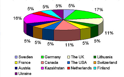
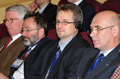
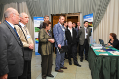
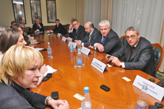
The 8-th Annual International Conference and Exposition "Laser Scanning and Digital Aerial Photography. Today and Tomorrow" was held in Moscow, 10-11 December in the President Hotel. The Conference was organised by the Society of Contribution to Development of Photogrammetry & Remote Sensing (RSPRS) in co-operation with the Russian Society of Surveyors. Geokosmos Group of Companies incorporating Geokosmos, Geolidar, Geopolygon and TerraImaging, acted as General Sponsor. Microsoft Vexcel and Trimble acted as Platinum and Gold Sponsors to the Conference. The Conference served as an effective tool for promoting scientific cooperation and research in Geoinformatics on a global scale. The Conference provided a platform for knowledge and experience sharing – delegates presented their reports bringing up the most up-to-date issues in Geodesy, Surveying, Mapping and Topography. More than 200 people participated in the Conference and represented companies and organizations from 16 countries. Officials, top managers, specialists in different fields of expertise from Russia, Finland, Germany, Austria, Switzerland, Canada, USA, etc. met with colleagues, partners, existing and potential customers – Picture 1.
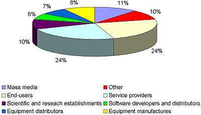
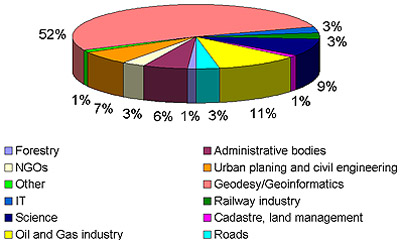
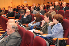
The analysis revealed that services providers as well as end-users of digital aerial imagery and LiDAR data prevail over the other categories of the target audience – Picture 2. The end-users were mainly from Russia. In 2008 the spectrum of business applications enhanced if compared to the previous year. When asked about areas of their activity, people referred, in the first instance, to geodesy and geoinformatics (53%), oil and gas industry, science and research, urban planning and civil engineering.
This year the Conference featured a new topic devoted to the technology of 3D mobile mapping, the development of new mobile laser scanning systems and software. The topic was raised by a number of the participants: Dr. R. Valerie Ussyshkin, Optech Inc. unveiled two new products, ALTM-Orion and Lynx, the capabilities of the products and the major performance advantages; Nikolaus Studnicka, RIEGL LMS, introduced the latest developments of RIEGL-laser scanners and processing software packages specially designed to meet the requirements of mobile mapping applications. Hannu Korpela, Terrasolid, raised the issue of the data calibration which is a crucial factor to reach an acceptable data accuracy quality. He told the audience about the Terrasolid software which is now, apart from airborne laser data processing, is applicable for calibrating and processing of mobile scanning data. Vladimir Egorov, Geokosmos, brought up the issue of the integration of mobile and airborne laser scanning data and presented a case study of a unique project. In September 2008 Geokosmos introduced the 3D Mobile Mapping System and using StreetMapper surveyed the first thousand kilometers of roads in Moscow and Moscow region. Right after the presentation Geokosmos demonstrated to the participants StreetMapper performance capabilities. Currently Geokosmos is the only Russian and CIS company which owns this type of equipment. Another topic which was focused on integrated technologies and relevant software when dealing with geospatial information provoked great interest as well. Irina Vetzel, ERDAS Inc., made an insight into ERDAS TITAN, an online network for sharing data across organizations and end users. This information, includes geospatial data, web services and location-based content.
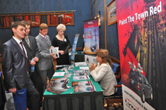
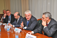
Presentations were made by regular Conference participants and new attendees. Svein Vatslid, Trimble, Conference Sponsor, presented its development strategy for geospatial imaging on the first day of the Conference, December 10, 2008. Trimble manifested its interest in active promotion of the recent acquisitions to the East European and Russian markets as these markets possess strong potential for implementation of Trimble’s new technologies as well as anew strategy for geospatial imaging, and the VIII International Conference was seen as an effective marketing tool for this promotion. Anders Ekelund, Airborne Hydrography AB, informed the audience about a new generation airborne topographic LiDAR system DragonEye; Julien Losseau, DIMAC Systems, on the latest product from the DiMAC family: the DiMACULTRALiGHT; Sergey Melnikov, Geokosmos, on the analysis of the Geoinformation market; Mustapha Doghaili, Lupos 3D, on LupoScan, software to efficiently process laser scanning data; Evgeniy Medvedev, Geolidar, on organization of training in applied laser scanning for production companies' personnel and University students; Gordon Petrie, University of Glasgow, on systematic oblique aerial photography for mapping, reconnaissance & visualization purposes using both single & multiple digital frame cameras; etc. The last year tendency of a marked increase in the number of presentations focusing on application and use of geoinformation technologies as well as on case studies of aerial and terrestrial survey projects could be traced this year as well: Nickolai Fomenko, KazGeoKosmos, talked about the application of Vexcel UltraCamX Camera in Kazakhstan; Alexander Skripkin, Jena Instrument, - on the recovery of design documentation of Friguia plant, Guinea, which refines bauxite into alumina. The recovery of the documentation is based on laser scanning methods. The Conference hosted an exposition demonstrating the latest innovations on the geodetic market, up-to-date equipment for aerial and terrestrial survey, software products. Among the exhibiting companies were Airborne Hydrography AB, DIMAC Systems, Lupos3D, Optech Inc., PERGAM, RIEGL LMS, Trimble.
For enquiries please contact Marketing Department, Geokosmos:
|
|