|
|
|
|
|
|
|
Geokosmos to conduct lidar survey of the French railways
13.07.2007
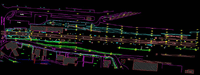
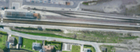
Russia-based company Geokosmos has successfully completed LiDAR survey of French national railways in France. Using combined airborne laser scanning and digital aerial photography technology Geokosmos surveyed that part of the railroads which connects Amiens and Bouillon and covers an area of 83 km. The captured data was used for producing of a large-scale digital topographic map (scale 1:500) and a digital orthophoto (GSD 5 cm) that will definitely help French National Railways Service to provide technical assessment of the French railways and its infrastructure. The project can be considered as a unique one in many aspects. Given tough requirements set up by the customer with regards to the accuracy of captured data, aerial laser scanning combined with aerial digital photography was conducted with high density of laser points – 7 points per 1 sq. m. Planimetric and height accuracy constituted 5 cm. When processing the acquired data Geokosmos specialists faced another challenge. It is a common knowledge that many classification systems and innumerable map legends exist, and maps and statistics from different countries, and in many cases even from the same country, are incompatible with each other. As a result Geokosmos specialists adapted and applied a map legend provided by the customer. The positive appraisal of the customer has once again demonstrated the efficiency of the airborne laser scanning technology, high quality of the data and wide range of its application areas including transportation mapping.
|
|