|
|
|
|
|
|
|
Geokosmos to complete a unique project
05.07.2007
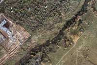
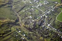
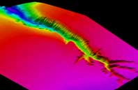
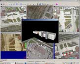
Geokosmos successfully completed one of its most interesting and major airborne projects which became a milestone in the Company’s history. The Administration of the Kstovo municipal district (a part of Nizhegorodskaya Oblast, 400 km north-east from Moscow) awarded Geokosmos a contract which stipulates surveying of the whole district territory and includes airborne laser scanning and digital aerial photography. To carry out the project, Geokosmos specialists installed onboard of Antonov-30 a unique airborne surveying complex which consists of an airborne laser scanner ALTM 3100, a large format digital camera Vexcel UltraCam D and two middle format Rollei cameras. The middle format cameras were installed at a right and left angles to produce oblique images which offer a vital benefit by adding a wealth of new features to the acquired data. The result is a revolutionary way to use aerial imagery that was unheard of just some years ago. Geokosmos provided the Administration of the Kstovo municipal district with high level accuracy data set comprising orthophotos (GSD 7 cm) of urban territories, DTM, DSM and digital aerial photos including oblique images. The output products were examined by the local Department for Geodesy and Cartography and got very positive appraisal. The materials are considered to be of high quality and meet the identified criteria. It is for the first time that orthophoto of such a high level of accuracy has been produced at the territory of CIS countries, particularly given the fact that the data of urban territories were acquired. Therefore this project can be truly regarded as a unique one. The output products provide a broad range of applications. In the first instance the created orthophotos will be used to update existing topographic maps of the Kstovo municipal district. DTM and DSM will form the basis for the creation of the municipal GIS. High resolution digital images produced by Vexcel UltraCam D along with the oblique images produced by Rollei cameras will serve for the municipal administration as an effective tool for traffic, housing and vegetation monitoring. It proves once again that the development of contemporary housing and utilities infrastructure is impossible without pioneering technologies which are becoming an essential part of everyday life. The above project also once again emphasizes the fact that Geokosmos is strongly involved into the development and research so that we can deliver to our clients high quality products they need to conduct their work.
|
|